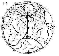
Introduction. The basic earthen property - is axial structural symmetry of its shell. This symmetry is evident (F.1, left). The plate tectonics deals with some other object, then the real axially structured Earth. We can percept the genesis of axial symmetry in one case only: if we know true tectonic position of cover basalts, which cloth 80 % of the planet (F.1, right). Structural earthen symmetry rejects the explanation of climate biocrisises (cold or greenhouse) by continent's drift.
Structural earthen mountain seams are mainly continental fold-thrust (geosyncline
- GS) zones and ocean ridges. In relief they are planetary mountain arcs. All
of them have their own geographical twins in earthen degree net at other hemisphere.
Cover basalt catastrophes coincide with geological period marks. Space-time
position of basalt fields in geotectonic cycle is: in space - rear of fold-thrust
zone, in time - post-orogenic and pra-taphrogenic act [1, 2]. Ocean flood
basalts are similar to continental traps (DSDP ).
Ages of ocean lavas (as continent trap ages) display, which of fold zones exactly
exists near or beneath their margins. From one geocycle to another fold zones
recede from inner earthen craton over their fronts (Africa) or aside the rears
(N.America). When even-aged fold zones collide mutually, their rear basalts
are connected also. Next tectonic act here is the creation of common taphrogen,
(riftogen) - oceanic ridge with its major rift and distinct volcanoes. Now anyone
can see the scheme-map (F.1, right) with earthen basalt shell of different ages
lavas and with global net of fold GS and post-GS taphrogenic zones in oceans.
F.1, left Principal scheme of global dislocated seams for both hemispheres
(jointly, traits). Center, 60,120╟l: Urals = Cordilleras and Tajmeria = Innuitian
(Southward-W.Indic = E. Pacific); 40 ╟j to W: Apsheron-Pont-Atlas-Mavritanians
= Mendocino-Mapmaker. Other: Ugarta = Hawaian; Walvis,= Tonga; Central Asian
= Appalachian and Greenville front; W. Pacific (Palau - Caroline line) = Mid
Atlantic etc.
F.1, right. Earthen basalt shell (DSDP data by author [1,2]). Bad investigate
regions out of shading. 1- 4 -ages of vergent fold zones, post-orogenic final
basalts, taphrogenic rifts: 1-hercicnides (late hercinides) 2-C/P, (P/T),
P/T (T/I), T/I (I/K); 2-cimmerides T/I, I/K, K/Pg; 3-nevadides
I/K, K/Pg, Pg/N; 4-laramides K/Pg, Pg/N, N/Q; late alpides now
at orogenic phase, cover basalts in its rears are absent; 5-ocean ridges; 6-fold
zones, faults; 7- cratons out of traps; 8 and 9-fordeeps (in frames) for Urals
and Cordilleras.
F.1
As example of ocean appearance: Cordilleras with their rear lavas
(Plato Columbia, ocean floor) southward of 30╟N meet front of another fold zone
with its rear basalts. Here synchronous lava covers are united mutually, and
oceanic ridge arises.
In the frames there are Urals with structural ensemble of final cover basalts
and Cordilleras - its geographical twin. Frontal fordeeps in hercinian (Urals)
and laramian (Cordilleras) cycles are on different sides of these mountains.
These fold zones (GS zones) were living since PE. At that time their fordeeps
and their final basalts were in contrary west and east places. General line
of Pra-Cordilleras went northward at that time, round of Bear province.
Cover basalt catastrophes, which are created in geological instant (mln y.?),
make biocrisises. At present many geologists have accepted meteoritic impact
model of climate change. Model says: one crater with Ж 100-200 km is enough
to produce the life renewal. At the moment of cover basalt fields creation millions
of craters are born. Huge masses of tuffs (pyroclasts) and then basalts flow
out from them. In tuffs there are shock-minerals and dust with Ir (because picrites
with Ir, Os, Au in many cases are the first explosions). The biocrisis scripts
at geological period marks, on the average of 30 mln years each are: I-cold,
pulsate glaciating (our planet as the Mars, but how much similar -is dreamy),
II-hotbed because of lava's evaporation (Earth as the Venus, but how much similar
-is dreamy), III-balance restoration by the plants (what is that in reality
and how long time- is dreamy). What does our pulsing glacial time mean ? Last
cover basalt epoch was 35 mln years ago. Is the end of it coming nowadays or
we are living now at its beginning? The last is more true. What is the rear
volcanites position - of Carpates (late orogenic ?), - of Syrian-Palmyrides
arc (early final in Plato Dras ?),- of Hymalayans
(late orogenic or early manifestations of final basalts with termal astenolenses
15-40 km deeps ?[3]). All these issues must have answers.
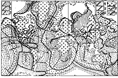
On the global map (F.2,left)[2] there are cover basalts for the time of famous
K/Pg biocrisis. 1- lava hills (a) and basaltic intrusives (b), with deposits,
which determine underlying lava floor age -"not younger then"; 2-
onland - ocean cover basalt provinces with better (a) or not good detection
(b); 3- vergent fold zones (a), and prospective oceanic fold zones (b); 4-ocean
ridges - taphrogens and renewal taphrogens.
F.2
On the scheme (F.2, right) central strips of earthen K/Pg volcanic planetary
rings are shown in their real global picture (compare with F.1, right), the
spiral crosses the N pole. 1,a,b-degree net for Pacific (a) and Atlantic (b)
hemispheres; 2-middle strips of K/Pg lavas for Pacific side with breaks and
with doubling near S.America; 3- middle lava strips for Atlantic side.
F.3
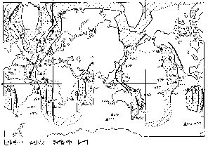
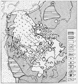 On the scheme-map
of the part of Siberian trap province (F.3, from many maps 1:2000) one can see
abundance some of oldestablished volcanic craters (small rings, note 7-10) under
the lavas (note 4). Lavas thick " 4 km in the N, southward lavas are degradated
(bottom tuffs - note 3). This P/T basalt field is one of many other post-hercinian
fields (see F.1, right). Near N map margin there is Popigai crater, possibly
meteoritic (its age, Pg/N, it is nearly the basalt fields of this young age)
and eventual the creator of its own biocrisis. It is very curiously after its
scale to compare it and other alike possible "cosmic" craters with
real earthen cover basalt provinces. All cover basalt fields have in their base
thousands of volcanic craters with 1-5 and 10-100, rarely 200 km in diameter.
These craters worked at huge territories at the same time and flickered above
the dikes and above big intrusions with displacing along them. These craters
had no appreciable superstructures. Their outputs - first ashes, than ashes
with lava bombs, with their fragments and with debris of rocks, etc.- exist
inside the layers with many slim lava coats, prior lava lakes. In author's opinion
now we see on the Io - Jovian satellite - global natural pyroclastic explosions
[4], which are alike the first phase of earthen cover basalt volcanism. These
conditions, with earthen detention of volatile components, dusts and with birth
of huge dark clouds make global colds at the cognate moments of biocrisises.
On the scheme-map
of the part of Siberian trap province (F.3, from many maps 1:2000) one can see
abundance some of oldestablished volcanic craters (small rings, note 7-10) under
the lavas (note 4). Lavas thick " 4 km in the N, southward lavas are degradated
(bottom tuffs - note 3). This P/T basalt field is one of many other post-hercinian
fields (see F.1, right). Near N map margin there is Popigai crater, possibly
meteoritic (its age, Pg/N, it is nearly the basalt fields of this young age)
and eventual the creator of its own biocrisis. It is very curiously after its
scale to compare it and other alike possible "cosmic" craters with
real earthen cover basalt provinces. All cover basalt fields have in their base
thousands of volcanic craters with 1-5 and 10-100, rarely 200 km in diameter.
These craters worked at huge territories at the same time and flickered above
the dikes and above big intrusions with displacing along them. These craters
had no appreciable superstructures. Their outputs - first ashes, than ashes
with lava bombs, with their fragments and with debris of rocks, etc.- exist
inside the layers with many slim lava coats, prior lava lakes. In author's opinion
now we see on the Io - Jovian satellite - global natural pyroclastic explosions
[4], which are alike the first phase of earthen cover basalt volcanism. These
conditions, with earthen detention of volatile components, dusts and with birth
of huge dark clouds make global colds at the cognate moments of biocrisises.
Ref: [1] Makarenko G.F. (1993), Cosmoinform, M, 280 p.(Rus). [2] Makarenko
G.F. (1997), Geoinformmark,
N3, Moscow, 96 p. (Rus)., [3] Owens T.J., Zandt G. (1997), Nature, 387,1 May,
pp. 37-47., [4] McEven A.S.,
Belton M.J.S. et al. (2000), Science, Vol.288, 19 May, pp 1193-1198.